ul. Firmowa 30, 05-152 Cząstków Polski
email: parker@parker.com.pl
Tel: +48 22 785 11 11
fax +48 22 785 09 99


Parker Poland Sp. z o.o. realizuje projekt w ramach działania 3.4. dotacje na Kapitał obrotowy Programu Operacyjnego Inteligentny Rozwój 2014-2020
Celem projektu jest:” Dofinansowanie do Kapitału Obrotowego – w związku ze spadkiem obrotów spowodowanych pandemią COVID-19, określonego we wniosku
o dofinasowanie nr POIR.03.04.00-14-0330/20”
Dofinansowanie projektu z UE: 127 128,00 PLN.


Kategorie produktów:
- Silniki spalinowe
- Silniki elektryczne
- Osprzęt i wyposażenie jachtów
-
Elektronika morska
-
SIMRAD
- Sugerowane wyposażenie
- Nawigacja
- Kartografia
- Radary
- Autopiloty
- Instrumenty nawigacyjne
- Rozrywka
- Bezpieczeństwo
- Radiokomunikacja i AIS
- Zdalne sterowanie
- SimNet
- Przetworniki
- Akcesoria
- Discontinued Products
- LOWRANCE
- B&G
- FUSION
- FLIR
- C-MAP
- NAVIONICS
- SHAKESPEARE
-
SIMRAD
- Łodzie
- Parker Ribs
- Pontony
- Łodzie Parker
- Poduszkowce – Hovercrafts
- Kamizelki ratunkowe ISP UK
- Morskie kaski ochronne GECKO
- JASON’S CRADLE
Nasze marki:


Certyfikaty:

RODO:
Navionics
Powerful plug-and-play electronic charting choices for supreme navigational awareness. Simply insert into your Simrad NSS, NSE or NSO chartplotter for the greatest detail possible.

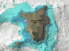
Navionics® Platinum+ 3D. |
 Navionics® Platinum+ 3D with satellite overlay.
|
|
Three levels of Navionics charts are available for your Simrad chartplotter: Ready to Navigate, Gold and Platinum+. These chart options provide the best in electronic marine charting with far more information than a paper chart alone and are incredibly easy to use and navigate with! |
||||||||||||||||||||||||||||||||||||||||||||||||||||||||||||||||||||||||||||||||||||||||||||||||
|
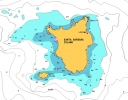
This charting provides detailed bathymetric charts along with depth contours, spot soundings, port plans, port service guides, navigation aids and more. It is the perfect charting for those who just want to get out and get moving with simple, easy to read information. Read more |
||||||||||||||||||||||||||||||||||||||||||||||||||||||||||||||||||||||||||||||||||||||||||||||||
|
A powerful boating and fishing reference tool, Gold level charting provides detailed bathymetric charts and all the benefits of Ready to Navigate charting plus tides, currents, wrecks, port plans, marsh areas, marine services, coastal roads and points of interest which include phone numbers. Read more |
||||||||||||||||||||||||||||||||||||||||||||||||||||||||||||||||||||||||||||||||||||||||||||||||
|
The most advanced technology and best imaging available in multidimensional charts, Platinum+ cartography builds on the power of Gold charting and provides complete coast pilot guides, panoramic pictures, 3D/2D views with satellite imagery, Points of Interest, aerial photography and built-in offshore fishing detail. Read more |
||||||||||||||||||||||||||||||||||||||||||||||||||||||||||||||||||||||||||||||||||||||||||||||||
|
|
||||||||||||||||||||||||||||||||||||||||||||||||||||||||||||||||||||||||||||||||||||||||||||||||
| ||||||||||||||||||||||||||||||||||||||||||||||||||||||||||||||||||||||||||||||||||||||||||||||||
|
With Simrad NSS, NSE and NSO models, TurboView greatly enhances the display of all Navionics charting for supreme situational awareness. The result is seamless zooming and with transition between 2D and 3D modes, improved shadowing for greater depth perception, real-time overlay of navigation data on 3D contour profiles, and a special FlyThru feature that integrates high-speed chart panning and zooming with photography for a new boater perspective. |
||||||||||||||||||||||||||||||||||||||||||||||||||||||||||||||||||||||||||||||||||||||||||||||||

Why update your chart? Water levels fluctuate, buoys change, and new data is constantly being added the Navionics chart database. We make over 10,000 changes every week! Freshest Data gives you access to Navionics’ most current database which includes the latest notices to mariners, updated tides and currents, port plans, and points of interest, improved bathymetric coverage, new data sets, pro staff data, updated coastlines and dock placement, and underwater structure such as road beds, foundations, bridges, creeks, ponds, and more.
New 2012 Navionics products are eligible for unlimited updates* to the nautical chart for one year. Freshest Data updates are available online for Gold and Platinum+ marine charts, HotMaps Premium and HotMaps Platinum lake maps for North America, and new downloadable regions. Visit the Navionics website for more details. |


Dostępne produkty
Navionics Platinum+
 Zabierz doznania nawigacyjne na całkowicie nowy poziom dzięki widokom 3D, zintegrowanej warstwie zobrazowania z powietrza oraz zdjęciom portów.
Navionics Gold
 Navionics Gold – Kartografia wgrana do wszystkich chartploterów Simrad NSS, NSE i NSO
Ready To Navigate
 Kontury głębokości, punktowe sondowanie, plany portów, przewodniki usług portowych, pomoce nawigacyjne, itp.